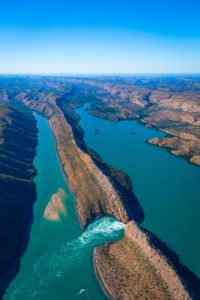
 This part of the Kimberley has been formed from rock formations of the Kimberley Basin but here rock folding has altered their orientation from nearly horizontal to folds with wave lengths varying from a few metres to kilometres and producing in places strata tilted with nearly vertical orientation. One major folding event occurred 540 million years ago and since then ongoing weathering and erosion have reduced the high mountains to plateaus, ridges and valleys. The ridges represent the stumps of the more resistant formations (King Leopold Sandstone, Warton Sandstone and Pentecost Sandstone) and the valleys, now flooded with sea water, have been formed where the less resistant formations (Carson Volcanics and Elgee Siltstone) once existed.
At the Horizontal Waterfalls, an interesting attraction found deep in Talbot Bay, intense folding has tilted the originally horizontal formations through 85 degrees. Stream weathering in the past cut down through joints in the near vertical strata forming gaps in the outer two ridges as water flowed out to sea through a valley in Talbot Bay. At this time the stream may have had to run across the continental shelf for many tens of kilometres westward of Yampi Peninsula to reach the sea. This stream allowed for the weathering and erosion of the two embayments we now see inside the gaps where the two more easily weathered, ‘weak’ formations were once found. The first gap is through a ridge of Pentecost Sandstone that separates Talbot Bay from the first embayment, the second gap is through a ridge of Warton Sandstone and it connects the two embayments. McLarty Range forms the innermost ridge and it is formed of King Leopold Sandstone. Prior to their weathering and erosion, Carson Volcanics occupied the second embayment and Elgee Siltstone occupied the first embayment and remnants of these rocks may still be found on the walls of each embayment.
 Cross section view of the geology of the Horizontal Waterfalls. Slug Island is made of the oldest rock, the King Leopold Sandstone (1840 million years old). Conceptually you could start on Slug Island and walk to the left towards the Horizontal Falls, and walk over 40 million of years strata, ending at the youngest rock, the Pentacost Sandstone (1800 million years old), which forms the wide gap. If you kept walking, you would go from young rock (Pentacost Sandstone) back over 40 million of years of strata, until you got to the oldest rock (King Leopold Sandstone) forming the McClarty Ranges.